
File:Insediamenti Agricoli.jpg

File originale (919 × 580 pixel, dimensione del file: 384 KB, tipo MIME: image/jpeg)
| Questo file proviene da Wikimedia Commons. La pagina di descrizione associata è riportata qui sotto. |
Dettagli
| Descrizione |
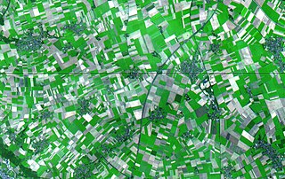
English: Simulated natural color scene shows a region in the German state of North Rhine Westphalia.
This simulated natural color scene shows a 30 by 36 km (19 by 22 miles) region in the German state of North Rhine Westphalia (located in midwestern Germany). The myriad rectangular patches are agricultural fields; light green hues show where crops are growing and grey hues show bare soil. Darker green hues show forested areas. The various blue-grey clusters of pixels seemingly linked together by dark thin lines are towns and villages connected by roads. The data used to produce this scene were acquired by the Advanced Spaceborne Thermal Emission and Reflection Radiometer (ASTER), flying aboard NASA's Terra satellite, on August 26, 2000. Italiano: Insediamenti agricoli: piccoli centri abitati e campi coltivati (Germania) |
| Data | |
| Fonte | https://earthobservatory.nasa.gov/IOTD/view.php?id=1642 |
| Autore | NASA Earth Observatory |
| Licenza (Riusare questo file) |
https://www.nasa.gov/multimedia/guidelines/index.html |
Licenza
| Questo file è nel pubblico dominio perché creato dalla NASA. La politica sul copyright della NASA afferma che «il materiale della NASA non è protetto da copyright a meno che non sia specificato altrimenti». (NASA copyright policy e JPL Image Use Policy). | ||
 |
Attenzione:
|
Cronologia del file
Fare clic su un gruppo data/ora per vedere il file come si presentava nel momento indicato.
| Data/Ora | Miniatura | Dimensioni | Utente | Commento | |
|---|---|---|---|---|---|
| attuale | 11:02, 26 mag 2018 | | 919 × 580 (384 KB) | JuTa | the other one is available at File:Lower rhine embayment lignite strip mines.jpg |
| 11:03, 8 set 2017 |  | 2 000 × 2 400 (4,36 MB) | Senator2029 | https://eoimages.gsfc.nasa.gov/images/imagerecords/1000/1642/aster_mines_deutschland_lrg.jpg | |
| 16:58, 25 nov 2016 |  | 919 × 580 (384 KB) | !Manihiki | User created page with UploadWizard |
Utilizzo del file
La seguente pagina usa questo file: